Wintry Weather This Wednesday Through Saturday
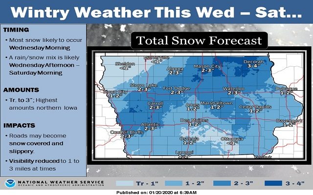

Another wintry weather system looks to impact Iowa starting this Wednesday morning and likely lasting into Saturday morning. Important to note, this system will be very much different than the system that impacted Iowa last weekend! There are two major reasons why this system will be different… 1.) Temperatures. On average, temperatures for this system will likely hover in the low to mid 30s. This means that precipitation will likely have a rain/snow mix tied with it… especially during the afternoon hours. In fact, some locations may be warm enough for more rain than snow, especially towards southern to south-central Iowa. 2.) Wind speeds. On average, wind speeds through much of this event will likely be near the 5 to 10 mph range. (This is in stark contrast to the previous event that had winds well over 30 mph throughout.) Therefore, visibility reductions will be more in the 1 to 3 mile range. At this time, most of the impacts are expected to come from snow accumulations leading to snow-covered and slippery surfaces, primarily untreated surfaces. These snow amounts are still subject to change as temperatures are very touchy… if it is slightly warmer during the overnight hours, precipitation may lean more towards the rain/snow mix, as opposed to mainly snow, which may lower this snowfall forecast slightly.