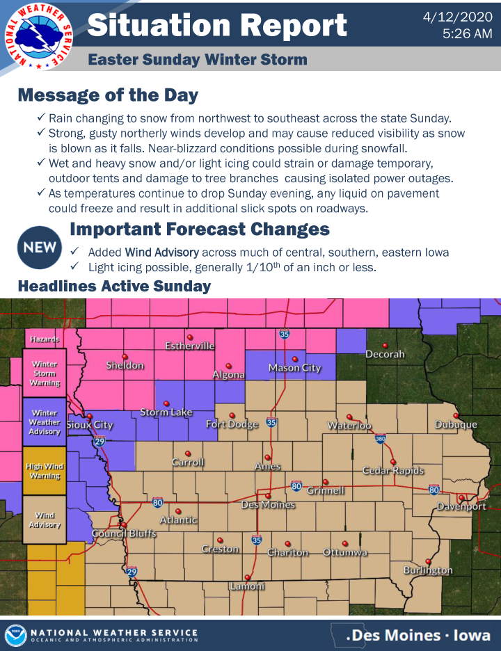
WINTER STORM WARNING for Kossuth, Worth, Winnebago, Mitchell, Mower MN, Freeborn MN and Faribault MN and a WINTER WEATHER ADVISORY for Cerro Gordo, Floyd, Hancock and Humboldt counties through early Monday morning.
…WINTER STORM WARNING REMAINS IN EFFECT UNTIL 1 AM CDT MONDAY FOR KOSSUTH, WORTH AND WINNEBAGO COUNTIES…
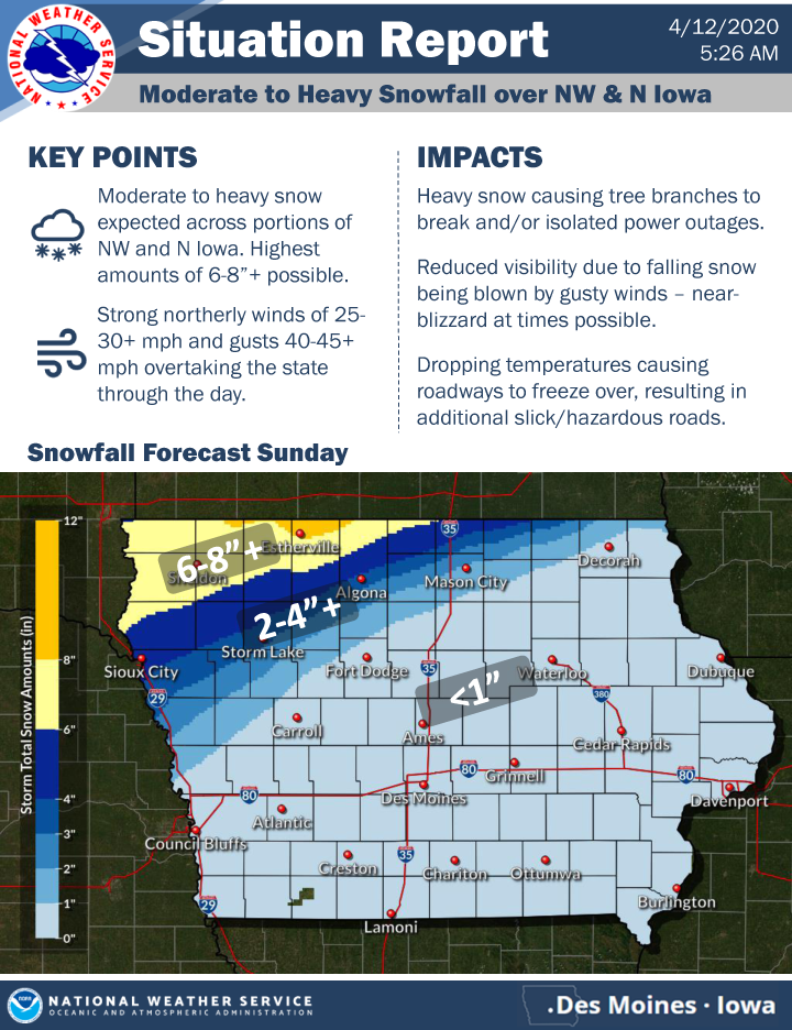
* WHAT…Heavy snow expected. Total snow accumulations of 4 to 9 inches. Light icing to around a tenth an inch possible. Winds gusting to around 40 to 50 mph.
* WHERE…Far Northwest and Northern Iowa.
* WHEN…From 7 AM Sunday to 4 AM CDT Monday.
* IMPACTS…Travel could be very difficult. Areas of blowing snow could significantly reduce visibility with near blizzard conditions possible. Heavy wet snow and/or light icing combined with the strong northerly winds may cause tree damage and possible isolated power outages.
PRECAUTIONARY/PREPAREDNESS ACTIONS…
If you must travel, keep an extra flashlight, food, and water in your vehicle in case of an emergency. The latest road conditions for the state you are calling from can be obtained by calling 5 1 1.
…WINTER STORM WARNING IN EFFECT UNTIL 7 AM CDT MONDAY FOR MITCHELL AND MOWER MN…
* WHAT…Heavy snow expected. Total snow accumulations of 5 to 10 inches. Winds gusting as high as 40 mph.
* WHERE…Portions of west central Wisconsin, north central Iowa and southeast Minnesota.
* WHEN…From 7 AM this morning to 7 AM CDT Monday.
* IMPACTS…Essential travel could be very difficult. Areas of blowing snow could significantly reduce visibility, possibly with near whiteout conditions at times this afternoon and evening. The hazardous conditions could impact the Monday morning commute.
PRECAUTIONARY/PREPAREDNESS ACTIONS…
If you must travel, keep an extra flashlight, food, and water in your vehicle in case of an emergency. The latest road conditions for the state you are calling from can be obtained by calling 5 1 1.
…WINTER WEATHER ADVISORY IN EFFECT UNTIL 1 AM CDT MONDAY HUMBOLDT, HANCOCK, FLOYD AND CERRO GORDO COUNTIES…
* WHAT…Snow expected. Total snow accumulations of 1 to 3 inches. Light icing to around a tenth of an inch possible. Winds gusting to around 40 to 50 mph.
* WHERE…Northwest and Northern Iowa.
* WHEN…From 10 AM Sunday to 4 AM CDT Monday.
* IMPACTS…Plan on slippery road conditions. Patchy blowing snow could significantly reduce visibility to less than 1 mile during times of heavier snow. Wet snow and/or light icing combined with the strong northerly winds may cause tree damage and possible isolated power outages.
PRECAUTIONARY/PREPAREDNESS ACTIONS…
Slow down and use caution while traveling. The latest road conditions for the state you are calling from can be obtained by calling 5 1 1.
…WINTER STORM WARNING IN EFFECT UNTIL 1 AM CDT MONDAY FOR FREEBORN AND FARIBAULT COUNTIES…
* WHAT…Heavy snow expected. Total snow accumulations of 5 to 8 inches. Winds gusting as high as 45 mph.
* WHERE…Portions of east central, south central and southeast Minnesota.
* WHEN…From 7 AM this morning to 4 AM CDT Monday.
* IMPACTS…Travel could be very difficult. Patchy blowing snow could significantly reduce visibility. Due to the heavy, wet nature of the snow, tree damage and power outages could occur.
PRECAUTIONARY/PREPAREDNESS ACTIONS…
If you must travel, keep an extra flashlight, food, and water in your vehicle in case of an emergency.
The latest road conditions for the state you are calling from can be obtained by calling 5 1 1.