❄Winter Storm with widespread heavy snowfall through Tuesday❄
❄❄❄Widespread Moderate to Heavy Snow Today through Tuesday❄❄❄
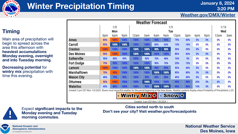
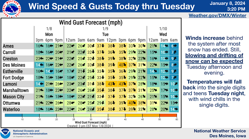
Moderate to heavy snow is still expected to spread across much of the state today. Light snow has already begun in portions of southeast Iowa and is expected to continue north and east through the afternoon hours. The heaviest snowfall rates will occur overnight tonight into tomorrow morning. Highest accumulations are still forecast for the southeastern half of the state where amounts of 6 to 12 inches are expected. Total accumulations diminish further north and east where accumulations will be closer to 4 to 8 inches. As the snow ends on Tuesday, winds will begin to increase with gusts of 35 to 40 mph or greater in the afternoon. This may result in periods of blowing or drifting snow Tuesday afternoon, even after snowfall ends.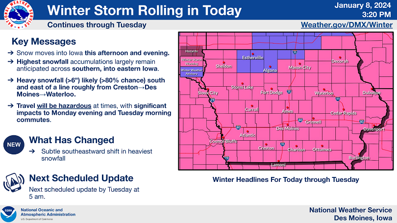
….WINTER STORM WARNING FOR CERRO GORDO, WRIGHT, FRANKLIN, BUTLER AND HANCOCK COUNTIES UNTIL 6 PM TUESDAY….
Heavy snow is expected. Total snow accumulations of 5 to 9 inches. Winds gusting as high as 40 mph by Tuesday afternoon.
…WINTER WEATHER ADVISORY UNTIL 6 PM TUESDAY FOR WORTH, WINNEBAGO AND KOSSUTH COUNTIES…
Snow is expected. Total snow accumulations of 3 to 5 inches. Blowing snow with winds gusting as high as 40 mph by Tuesday.
…WINTER STORM WARNING UNTIL 6 AM WEDNESDAY FOR FLOYD AND MITCHELL COUNTIES…
Heavy snow is expected. Total snow accumulations of 6 to 11 inches. Winds gusting as high as 40 mph.
…WINTER WEATHER ADVISORY UNTIL NOON TUESDAY FOR FREEBORN AND FARIBAULT COUNTIES IN SOUTHERN MINNESOTA…
Snow is expected. Total snow accumulations of 3 to 5 inches.
….WINTER WEATHER ADVISORY UNTIL 6 AM WEDNESDAY FOR MOWER COUNTY IN SOUTHERN MINNESOTA…
Snow is expected. Total snow accumulations of 3 to 5 inches.