⚠Very Dangerous Winter Storm Expected Tonight Into Friday Night⚠
…Very Dangerous Winter Storm Expected Tonight into Friday Night…
…Life threatening Wind Chills Expected Saturday Night into Early Next Week…
A multi-faceted severe winter storm is set to affect Iowa tonight into Friday evening. This dangerous storm starts this evening with snow spreading into the state and persisting into Friday with heavy accumulations. Winds then increase Friday morning with life threatening blizzard conditions expected into Friday afternoon and Friday night.
Travel will become very difficult by Friday morning and may be impossible in some rural areas Friday afternoon and Friday night. Blowing snow will significantly reduce visibility with whiteout conditions. The dangerously cold wind chills could cause frostbite on exposed skin in as little as 10 minutes. These temperatures and wind chills can be life threatening for stranded motorists.
Storms of this magnitude are fairly rare with recurrence around once or twice per decade. Travel is not recommended except if absolutely necessary, especially by Friday afternoon into the evening.
If you must travel, keep an extra flashlight, food, and water in your vehicle in case of an emergency. Travel should be restricted to emergencies only.
If you must travel, have a winter survival kit with you. If you get stranded, stay with your vehicle. Monitor the latest forecasts for updates on this situation.
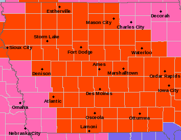
…….WINTER STORM WARNING IN EFFECT UNTIL 10 AM CST FRIDAY….BLIZZARD WARNING IN EFFECT FROM 10 AM FRIDAY TO 6 AM CST SATURDAY…WIND CHILL WATCH IN EFFECT FROM SATURDAY EVENING THROUGH TUESDAY MORNING FOR CERRO GORDO, WORTH, WINNEBAGO, HANCOCK, KOSSUTH, WRIGHT, FRANKLIN AND BUTLER COUNTIES……
For the Winter Storm Warning, heavy snow is expected. Total snow accumulations of 6 to 10 inches. For the Blizzard Warning, life threatening conditions are expected. Northwest winds are forecast to gust up to 45 mph with frequent visibilities of one quarter mile or less. For the Wind Chill Watch, dangerously cold wind will occur with values as low as 30 to 45 below zero..
…WINTER STORM WARNING UNTIL 9 AM SATURDAY FOR FLOYD, MITCHELL AND MOWER COUNTY IN SOUTHERN MINNESOTA…
Heavy snow is expected. Total snow accumulations of 7 to 12 inches. Winds gusting as high as 40 mph.
….WINTER STORM WARNING UNTIL 6 AM SATURDAY FOR FREEBORN AND FARIBAULT COUNTY IN SOUTHERN MINNESOTA….WIND CHILL WATCH FROM SATURDAY EVENING THROUGH TUESDAY MORNING…
For the Winter Storm Warning, heavy snow is expected. Total snow accumulations of 5 to 8 inches. Winds gusting as high as 35 mph. For the Wind Chill Watch, dangerously cold wind chills are possible. Wind chills as low as 35 below zero.