⚠ Blizzard Conditions Into Saturday Morning ⚠
…Very Dangerous Winter Storm Expected through Friday Night…
…Life Threatening Wind Chills Expected Saturday Night into Early Next Week…
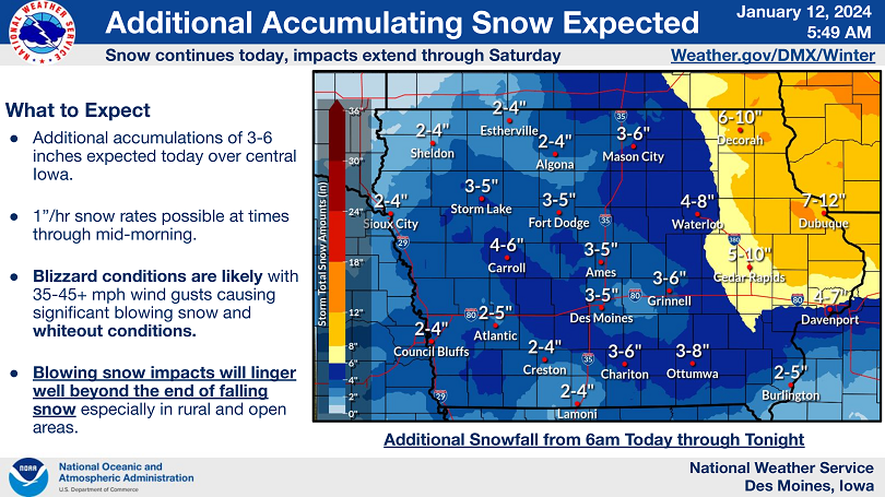
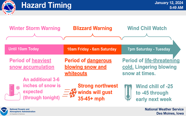
A multi-faceted dangerous winter storm will continue to affect Iowa this morning into Saturday. This dangerous storm will continue to bring snow across the state throughout the day today with additional accumulations of 4 to 8 inches forecast. Winds will also increase through this morning, with life threatening blizzard conditions expected by this afternoon into early Saturday. Dangerous temperatures follow into the weekend through early next week, with wind chill values down to 45 below zero expected.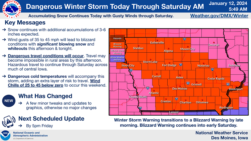
….BLIZZARD WARNING IN EFFECT UNTIL 6 AM CST SATURDAY…WIND CHILL WATCH IN EFFECT FROM SATURDAY EVENING THROUGH TUESDAY MORNING FOR CERRO GORDO, WORTH, WINNEBAGO, HANCOCK, KOSSUTH, WRIGHT, FRANKLIN AND BUTLER COUNTIES…
For the Blizzard Warning, life threatening conditions are expected. Winds gusting as high as 45 mph. Visibilities below one quarter of a mile will be common with whiteout conditions. For the Wind Chill Watch, dangerously cold wind chills. Wind chills of 30 to 45 below zero are expected.
…WINTER STORM WARNING UNTIL 9 AM SATURDAY FOR FLOYD, MITCHELL AND MOWER COUNTY IN SOUTHERN MINNESOTA…
Heavy snow. Additional snow accumulations of 5 to 11 inches. Winds gusting as high as 40 mph this afternoon and evening producing blowing and drifting snow in open areas.
….WINTER STORM WARNING UNTIL 6 AM SATURDAY FOR FREEBORN AND FARIBAULT COUNTY IN SOUTHERN MINNESOTA….WIND CHILL WATCH FROM SATURDAY EVENING THROUGH TUESDAY MORNING…
For the Winter Storm Warning, steady snow. Additional snow accumulations of 3 to 5 inches. Winds gusting near 45 mph. For the Wind Chill Watch, dangerously cold wind chills possible. Wind chills as low as 40 below zero.