WINTER STORM WARNING remains in effect through 3 AM Saturday. Moderate to heavy snow expected.
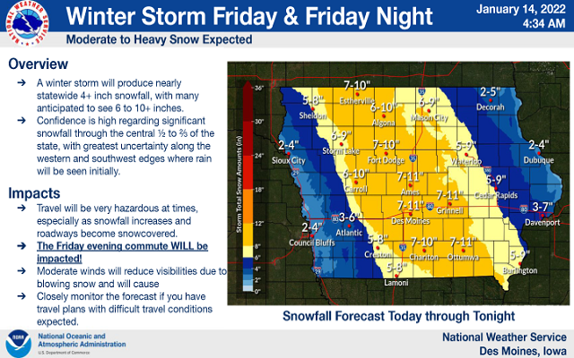
A winter storm will affect northern Iowa and southern Minnesota today and tonight. Widespread amounts of 6 to 10 inches of snow is expected across the warning area with locally higher amounts possible.
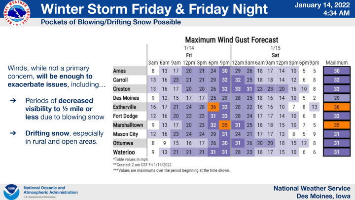
Winds will be out of the east to northeast and will increase to 15 to 25 mph with a few gusts over 30 mph tonight. The winds, combined with snow, will yield very low visibilities at times and produce pockets of blowing and drifting snow, particularly in open, rural areas.
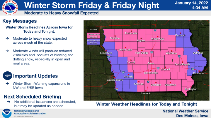
…WINTER STORM WARNING REMAINS IN EFFECT UNTIL 3 AM CST SATURDAY FOR CERRO GORDO, WORTH, WINNEBAGO, HANCOCK, KOSSUTH, WRIGHT, FRANKLIN AND BUTLER COUNTIES…
Heavy snow is expected. Total snow accumulations of 6 to 10 inches, with locally higher amounts possible.
…WINTER STORM WARNING REMAINS IN EFFECT UNTIL 3 AM CST SATURDAY FOR FLOYD AND MITCHELL COUNTIES…
Heavy snow is expected. Total snow accumulations of 5 to 8 inches.
…WINTER WEATHER ADVISORY REMAINS IN EFFECT UNTIL MIDNIGHT CST TONIGHT FOR MOWER MN…
Areas of freezing drizzle, then snow. A glaze of ice is possible. Snow accumulations of 3 to 5 inches.
…WINTER STORM WARNING REMAINS IN EFFECT UNTIL 9 PM CST THIS EVENING FOR FREEBORN AND FARIBAULT MN…
Heavy snow is expected. Total snow accumulations of 6 to 10 inches.

For the complete county by county break down of the weather alerts in effect from the National Weather Service in Des Moines. Click below!