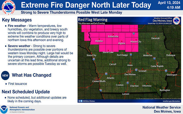
ISU launches ‘zoomable’ state map to track water quality projects
Water quality improvement projects underway across Iowa are now being mapped by the Iowa Nutrient Research Center at Iowa State University. Kay Stefanik, the center’s assistant director, says a website that features a “zoomable” map is devoted to the roughly four-dozen projects. Stefanik says there’s a range of projects being monitored with color-coded pins.
“A couple different categories of projects that we’re looking at, they’re edge of field, land management and nutrient management,” Stefanik says. “Looking at, for edge of field, how wetlands might help to remove nitrates from water coming off of agricultural settings, especially from tile drainage.” In addition, the map is being used to track land management, where strips of prairie vegetation are being interspersed with crops to reduce the movement of sediment and phosphorus from the surface.
“We also have nutrient management projects,” Stefanik says. “That looks at how the application, things like timing of fertilizer or manure application, the source of the manure or fertilizer can impact the nutrients coming off of the agricultural field.” She says it’s hoped a wide array of Iowans will use the map to learn about the efforts being made toward improving our water quality.
“It can be used by the general public to see what’s going on throughout the state, maybe what’s going on in their county at their local ISU farm,” Stefanik says. “We’re hoping it might also be used by researchers to see what other water quality projects are going on throughout the state.” Stefanik says significant progress is being made to reduce nutrient levels in Iowa’s waterways, though she says much more work remains to be done.
Learn more at: https://www.cals.iastate.edu/inrc/map/all