BLIZZARD WARNING for Cerro Gordo, Worth, Winnebago, Hancock, Wright, Franklin until 6:00 PM
January 18, 2020 6:36AM CST
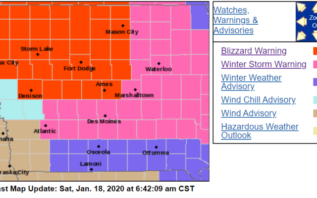
FOR THE LATEST WEATHER WARNINGS AND ADVISORIES, CLICK HERE


URGENT - WINTER WEATHER MESSAGE
National Weather Service Des Moines IA
314 AM CST Sat Jan 18 2020

...Blizzard Conditions in Northern Iowa Today...

.Potent northwest winds of 30 to 40 mph with gust to 45 to 50 mph
are anticipated this morning and throughout much of the day today
over northern Iowa. Light snow is also anticipated and with the
fresh snow pack from Friday`s snowfall, widespread blowing snow
is forecast and blizzard conditions are expected over northern
Iowa. Further south, winds are forecast to be slightly less but
still can expect gusts to 40 to 45 mph at times. Significant
blowing and drifting snow is anticipated and near whiteout
conditions may occur, especially in rural areas. In addition to
the major visibility restrictions, temperatures will drastically
drop throughout the day and with the potent winds, dangerously
cold wind chill values well below zero are likely by this
afternoon and evening.

IAZ006-016-017-025-026-036-037-047-048-181715-
/O.EXA.KDMX.BZ.W.0001.200118T1200Z-200119T0000Z/
/O.EXT.KDMX.WS.W.0002.000000T0000Z-200118T1200Z/
Winnebago-Hancock-Cerro Gordo-Wright-Franklin-Hamilton-Hardin-
Boone-Story-
Including the cities of Forest City, Lake Mills, Garner, Britt,
Kanawha, Mason City, Clear Lake, Eagle Grove, Clarion, Belmond,
Hampton, Webster City, Iowa Falls, Eldora, Ackley, Boone,
and Ames
314 AM CST Sat Jan 18 2020

...WINTER STORM WARNING NOW IN EFFECT UNTIL 6 AM CST EARLY THIS
MORNING...
...BLIZZARD WARNING IN EFFECT FROM 6 AM THIS MORNING TO 6 PM CST
THIS EVENING...

* WHAT...Areas of freezing drizzle to switch to light snow when
  the strong northwest winds begin by around sunrise. Then
  blizzard conditions are expected, especially in rural areas
  from wind gusts to 40 to 50 mph for much of the day.

* WHERE...Northern Iowa.

* WHEN...This morning through the afternoon hours today.

* IMPACTS...Treacherous travel conditions from the already snow
  and ice packed roads and then the blustery northwest winds
  causing major visibility restrictions. Gusty winds may damage
  tree limbs and power lines and lead to power outages.

* ADDITIONAL DETAILS...Temperatures will drop drastically today
  and dangerously cold wind chill values are anticipated by this
  afternoon and tonight.  Tow bans remain in effect for several
  counties in the warning.

PRECAUTIONARY/PREPAREDNESS ACTIONS...

If you must travel, keep an extra flashlight, food, and water in
your vehicle in case of an emergency.

Travel should be restricted to emergencies only. If you must
travel, have a winter survival kit with you. If you get stranded,
stay with your vehicle.

The latest road conditions for the state you are calling from can
be obtained by calling 5 1 1.


=======================
Worth-
Including the cities of Northwood and Manly
637 AM CST Sat Jan 18 2020

...BLIZZARD WARNING IN EFFECT UNTIL 6 PM CST THIS EVENING...

* WHAT...Blizzard conditions. Winds gusting as high as 50 mph with
  visibilities under one quarter of a mile at times.

* WHERE...North Central Iowa.

* WHEN...Until 6 PM CST this evening.

* IMPACTS...Treacherous travel conditions from the already snow
  and ice packed roads and then the blustery northwest winds
  causing major visibility restrictions. Gusty winds may damage
  tree limbs and power lines and lead to power outages.

* ADDITIONAL DETAILS...Temperatures will drop drastically today
  and dangerously cold wind chill values are anticipated by this
  afternoon and tonight. Tow bans remain in effect for several
  counties in the warning.

PRECAUTIONARY/PREPAREDNESS ACTIONS...

Travel should be restricted to emergencies only. If you must
travel, have a winter survival kit with you. If you get stranded,
stay with your vehicle.

The latest road conditions for the state you are calling from can
be obtained by calling 5 1 1.


