Blizzard Conditions Thursday morning into Friday morning. Dangerous travel Thursday.
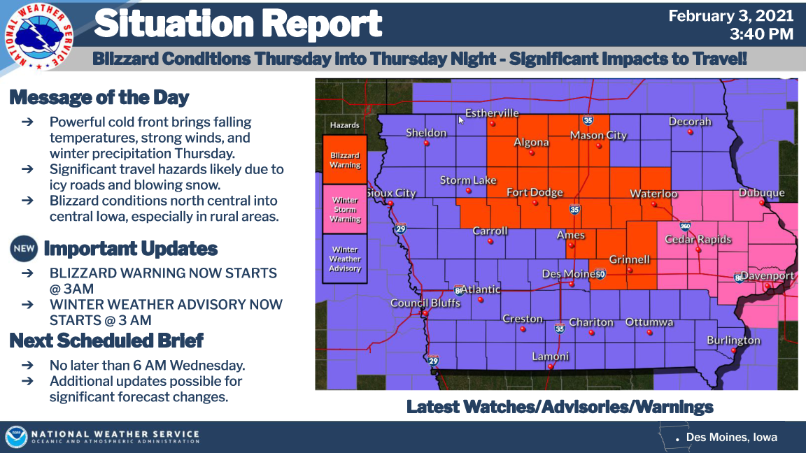
A powerful cold front moves through the area Thursday morning and afternoon bringing strong northwest winds, falling temperatures and wintry precipitation. Significant impacts to travel conditions are likely through the day Thursday into Thursday night.
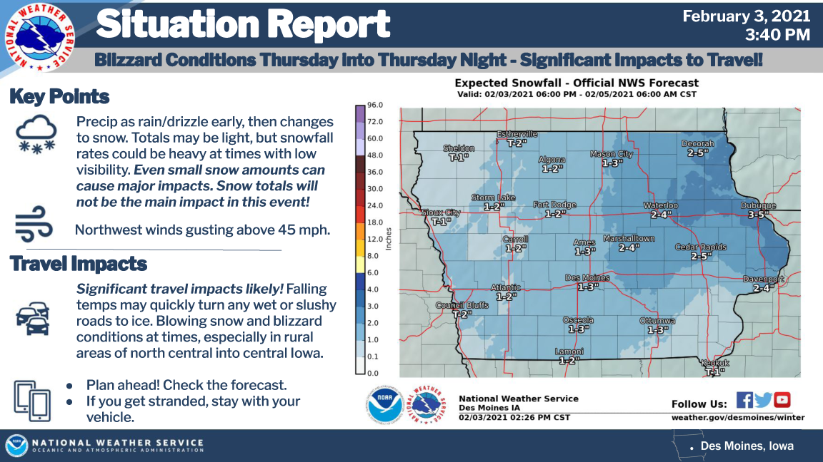
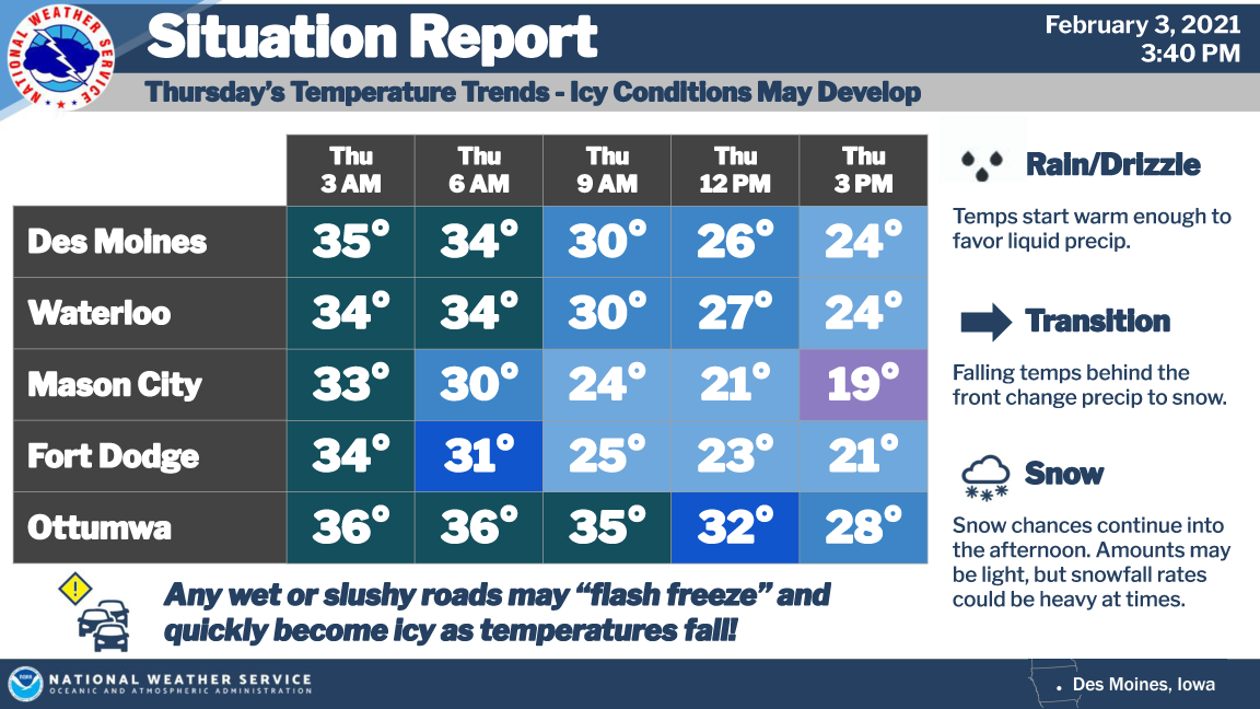
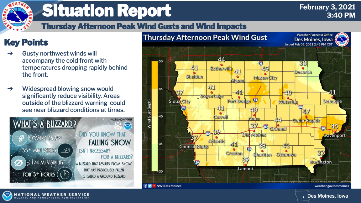
Scattered precipitation will initially start as rain or drizzle tonight into Thursday morning before the front quickly crosses the area from west to east. Any wet or slushy roads may flash freeze and quickly become icy as temperatures fall. Strong northwest winds gusting above 45 mph will create widespread blowing snow and potential blizzard conditions at times, especially in rural areas of north central into central Iowa.
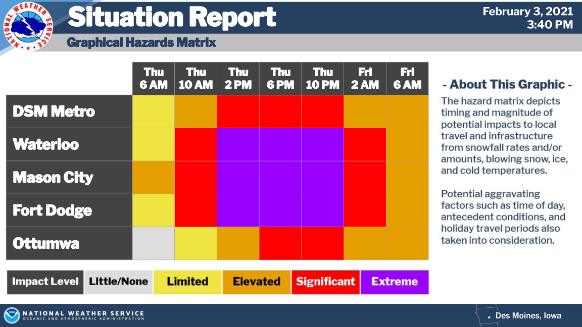
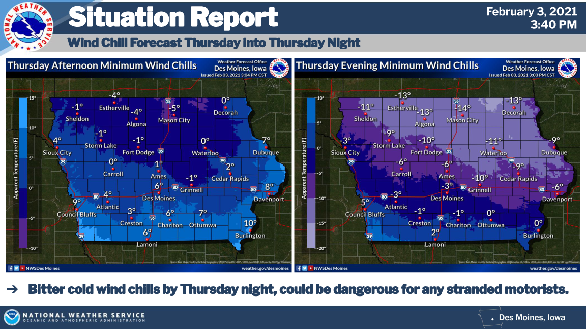
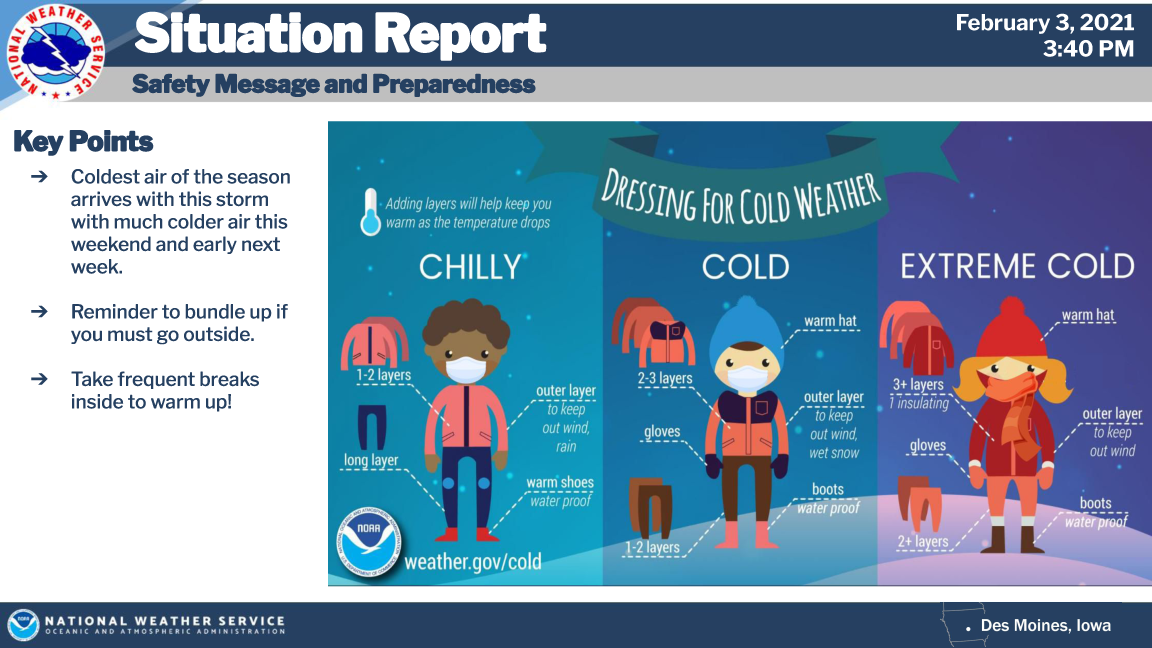
Snowfall totals are not expected to be heavy, but even light amounts may be enough to worsen impacts. Wind chills fall below zero by Thursday evening into Thursday night, which could serve as another hazard should motorists become stranded.
Those with travel plans are highly encouraged to closely monitor for changing weather conditions and consider alternate plans if at all possible. Late afternoon and evening commuters should note that conditions may be dramatically worse compared to the morning hours.
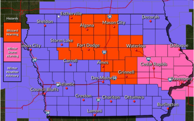
…BLIZZARD WARNING IN EFFECT FROM 3 AM THURSDAY TO 6 AM CST FRIDAY FOR CERRO GORDO, WORTH, WINNEBAGO, HANCOCK, KOSSUTH AND WRIGHT COUNTIES….
Blizzard conditions expected. Total snow accumulations of 2 to 4 inches. Winds gusting as high as 45 mph. Visibilities One- quarter mile or less. Travel should be restricted to emergencies only. If you must travel, have a winter survival kit with you. If you get stranded, stay with your vehicle.
…BLIZZARD WARNING IN EFFECT FROM 6 AM THURSDAY TO 6 AM CST FRIDAY FOR FRANKLIN AND BUTLER COUNTIES…
Blizzard conditions expected. Total snow accumulations of 2 to 4 inches. Winds gusting as high as 45 mph. Visibilities One- quarter mile or less.Travel should be restricted to emergencies only. If you must travel, have a winter survival kit with you. If you get stranded, stay with your vehicle.
…WINTER WEATHER ADVISORY FROM 3 AM THURSDAY UNTIL MIDNIGHT THURSDAY NIGHT FOR FLOYD, MITCHELL AND MOWER MN…
Snow expected. Accumulations of 1 to 3 inches. Winds gusting as high as 40 mph. Drifting and blowing snow.
…WINTER WEATHER ADVISORY FROM 3 AM TO 9 PM THURSDAY FOR FARIBAULT COUNTY IN SOUTHERN MINNESOTA…
Snow expected, along with some freezing drizzle and patchy blowing snow. Total snow accumulations of up to two inches. Winds gusting as high as 35 mph.
…WINTER WEATHER ADVISORY IN EFFECT FROM 3 AM THURSDAY TO MIDNIGHT CST THURSDAY NIGHT FOR FREEBORN COUNTY IN SOUTHERN MINNESOTA…
Mixed precipitation expected, although mainly snow will occur after 7 AM. Total snow accumulations of 2 to 4 inches and ice accumulations of a light glaze. Winds gusting as high as 35 mph.
For more on the weather headlines in effect for our listening area click below!