A WINTER STORM WARNING Is In Effect From Late Tonight Through Monday Afternoon
…Quick Hitting Spring Storm to Bring Moderate to Heavy Snow to Northern Iowa Late Tonight into Monday…
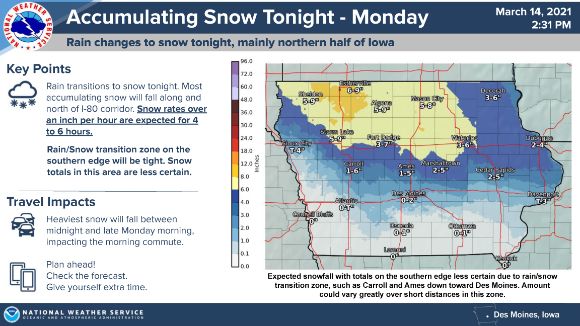
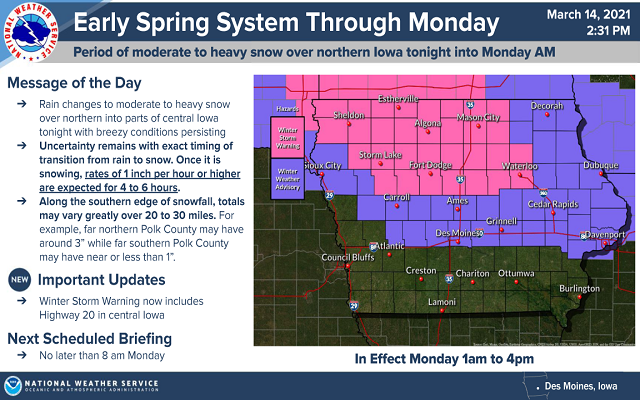
.A strong early spring storm system will impact Iowa into Monday. A majority of the snow accumulation will be north of Interstate 80, but some very minor accumulations could be as far south as around Highway 92. Northern Iowa will see snow accumulations top 6 inches with areas along portions of the Iowa/Minnesota border around 8 to 9 inches. The heaviest snow will fall between midnight and noon Monday. This will adversely impact the Monday morning commute with snow rates over an inch per hour over much of the warned area late tonight and Monday morning.
…WINTER STORM WARNING IN EFFECT UNTIL 4 PM MONDAY FOR CERRO GORDO, WORTH, WINNEBAGO, HANCOCK, WRIGHT, KOSSUTH, FRANKLIN AND BUTLER COUNTIES…
Heavy wet snow expected. Total snow accumulations of 5 to 7 inches. Winds could gust as high as 35 mph.
…WINTER STORM WARNING IN EFFECT UNTIL 4 PM MONDAY FOR FLOYD AND MITCHELL COUNTIES…
Heavy mixed precipitation expected. Total snow accumulations of 4 to 6 inches and ice accumulations of a light glaze. Winds gusting as high as 30 mph will likely create some drifting snow.
…WINTER WEATHER ADVISORY UNTIL 4 PM MONDAY FOR MOWER COUNTY IN SOUTHERN MINNESOTA…
Mixed precipitation expected. Total snow accumulations of 3 to 5 inches and ice accumulations of a light glaze. Winds gusting as high as 35 mph will likely create some drifting snow.
…WINTER STORM WARNING UNTIL 4 PM MONDAY FOR FREEBORN AND FARIBAULT COUNTIES…
Heavy mixed precipitation expected. Total snow accumulations of 5 to 8 inches and ice accumulations of a light glaze.
For More Information On The Weather Alerts In Effect For Our Area Click Below!