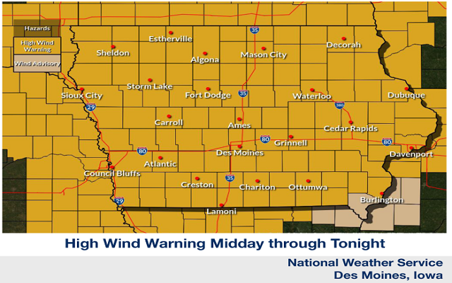
A HIGH WIND WARNING is in effect through early Thursday morning.
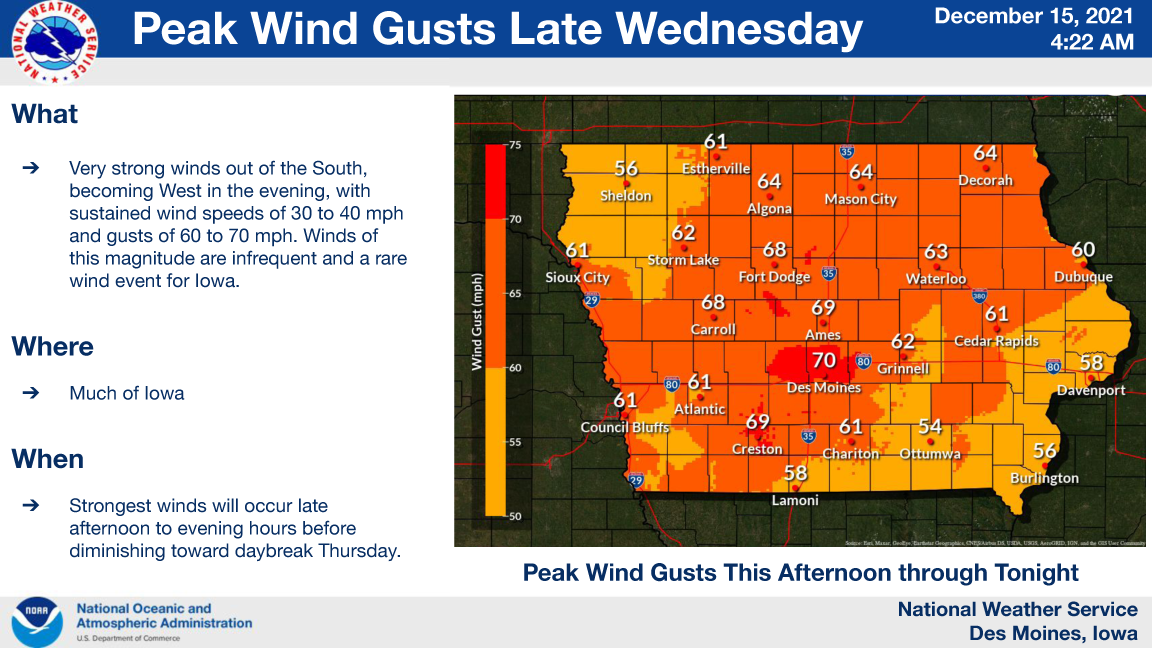
A rare wind event is expected across much of Iowa today. The day will start with brisk south winds, but they are expected to sharply increase further by the later afternoon and evening hours.
Sustained wind speeds should reach 30 to 40 mph with peak wind gusts of 60 to 70 mph before diminishing somewhat late tonight toward sunrise Thursday.
A High Wind Warning is in effect. Tree and power line damage may occur with some power outages. Secure loose objects and holiday decorations. Any fires may spread quickly with areas of blowing dust as well.
…A HIGH WIND WARNING IS IN EFFECT UNTIL 3 AM THURSDAY FOR CERRO GORDO, WORTH, WINNEBAGO, HANCOCK KOSSUTH, FRANKLIN AND BUTLER COUNTIES…
* WHAT…South to southwest winds 30 to 40 mph with gusts of 60 to 70 mph possible. Winds will become more westerly later this evening.
* WHERE…Much of Iowa.
* WHEN…From 3 PM Wednesday to 3 AM CST Thursday.
* IMPACTS…Damaging winds may blow down trees and power lines. Power outages are expected. Travel will be difficult, especially for high profile vehicles. Fires may spread quickly, with blowing dust possible as well.
PRECAUTIONARY/PREPAREDNESS ACTIONS…
People should avoid being outside in forested areas and around trees and branches. If possible, remain in the lower levels of
your home during the windstorm, and avoid windows. Use caution if you must drive.
…A HIGH WIND WARNING IS IN EFFECT UNTIL MIDNIGHT TONIGHT FOR WRIGHT COUNTY…
* WHAT…South to southwest winds 30 to 40 mph with gusts of 60 to 70 mph possible. Winds will become more westerly later this evening.
* WHERE…Much of Iowa.
* WHEN…From noon Wednesday to midnight CST Wednesday night.
* IMPACTS…Damaging winds may blow down trees and power lines. Power outages are expected. Travel will be difficult, especially for high profile vehicles. Fires may spread quickly, with blowing dust possible as well.
PRECAUTIONARY/PREPAREDNESS ACTIONS…
People should avoid being outside in forested areas and around trees and branches. If possible, remain in the lower levels of
your home during the windstorm, and avoid windows. Use caution if you must drive.
…HIGH WIND WARNING NOW IN EFFECT UNTIL 6 AM CST THURSDAY FOR MITCHELL, FLOYD AND MOWER MN…
* WHAT…South winds 30 to 40 mph turning southwest with gusts up to 65 mph expected. Storms this evening could produce locally higher gusts.
* WHERE…Chickasaw, Floyd, Allamakee, Winneshiek, Clayton, Mitchell, Howard and Fayette Counties.
* WHEN…From 6 PM this evening to 6 AM CST Thursday.
* IMPACTS…Damaging winds tonight will blow down trees and power lines. Widespread power outages are expected which could mean the loss of home heating, possibly for a prolonged period of time. Travel will be difficult, especially for high profile vehicles. Empty semi-trailers will run the risk of being blown over.
PRECAUTIONARY/PREPAREDNESS ACTIONS…
People should avoid being outside in forested areas and around trees and branches. If possible, remain in the lower levels of
your home during the windstorm, and avoid windows. Use caution if you must drive.
…HIGH WIND WARNING NOW IN EFFECT UNTIL 6 AM CST THURSDAY FOR FREEBORN AND FARIBAULT COUNTIES IN SOUTHERN MINNESOTA…
* WHAT…Southwest winds 30 to 40 mph with gusts up to 65 mph expected.
* WHERE…Watonwan, Blue Earth, Waseca, Steele, Martin, Faribault and Freeborn Counties.
* WHEN…From 6 PM this evening to 6 AM CST Thursday.
* IMPACTS…Damaging winds will blow down trees and power lines. Widespread power outages are expected. Travel will be
difficult, especially for high profile vehicles. Hazardous driving conditions due to low visibility.
* ADDITIONAL DETAILS…Widespread wind damage may also occur with a line of thunderstorms early this evening. Some wind gusts may exceed 80 mph.
PRECAUTIONARY/PREPAREDNESS ACTIONS…
People should avoid being outside in forested areas and around trees and branches. If possible, remain in the lower levels of
your home during the windstorm, and avoid windows. Use caution if you must drive.